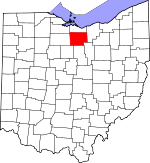
Find Public Records in Huron County, Ohio
This page lists public record sources in Huron County, Ohio. Additional resources can be found on our Ohio State Public Records page, on city pages, and on topic pages using the navigation above.
General information about Huron County
|
Population: 60,404 Area: 493 sq. miles County Seat: Norwalk |
Area Code(s): 419 Time Zone: Eastern |
Huron County is named after the Huron Tribe, which was originally located in Canada; some Huron moved into Ohio in the late 17th century. Formed in 1809, Huron County was reorganized in 1815 and parts were distributed to neighboring counties. The county was part of the Connecticut Western Reserve, an area that was originally claimed by Connecticut Colony and later ceded to the new United States government or sold to private land developers. Huron County has three small cities, 7 villages, and 19 townships. Norwalk, with a population of 17,000, is the county seat and largest city. Norwalk and several of the villages and townships in Huron County are named after places in Connecticut. Adjacent counties include Erie on the north, Lorain on the east, Ashland on the southeast, Richland on the south, Crawford on the southwest, Seneca on the west, and Sandusky on the northwest. Take a look at the categories below for a multitude of public records and documents, including offender and inmate records, public health inspections, and tax records. [1]
Sources:
|
Free Directory
|
Ohio Court Records and other Resources
Links to state and local court records, general Ohio court information, directory of courts, and online resources for courts in Ohio.
|
|
|
Free Directory
|
Huron County Court Directory
Directory of court locations in Huron County, Ohio. Includes local links to searching court records, dockets, legal research, self help, and more.
|
|
|
Free Search
|
Property Search and Mapping
Search for Huron County property taxes, assessments, parcel maps, and sales history by parcel number, owner name, or address.
|
Assessor, Auditor
Huron County Auditor
12 East Main St., Suite 300, Norwalk, OH 44857 Phone: (419) 668-4304 Fax: (419) 663-6948 |
|
Free Search
|
Recorded Document Search
Search Huron County recorded land documents by name, book and page, or instrument number.
|
Recorder of Deeds
Huron County Recorder
12 East Main St., Norwalk, OH 44857 Phone: (419) 668-1916 Fax: (419) 663-4052 |
|
Free Search
|
Registered Sex Offenders
Search for registered sex offenders in Huron County by address or name. Details include name, photo, aliases, registration number, physical description, address, offenses, and conviction dates.
|
|
|
Free Search
|
Inmate Search
Search for Huron County inmate records through Vinelink by offender ID or name. Details include offender name, date of birth, offender ID, custody status, reporting agency, current location, and scheduled release date.
|
Sheriff's Office and Jail
Huron County Sheriff's Office and Jail
255 Shady Lane Drive, Norwalk, OH 44857 Phone: (419) 668-6912 |
|
Free Search
|
Huron County Census Information Summary
Huron County statistics for population, ethnicity, housing, geography and businesses. From the U.S. Census Bureau.
|
|
|
Free Search
|
Government Jobs
View Huron County government job openings and employment information.
|
|
|
Free Search
|
Ohio Offender Search
Search for offenders currently incarcerated in an Ohio prison or offenders who are currently under Ohio Department of Rehabilitation and Correction supervision. Details include name, photo, number, date of birth, admission date, status, offenses, and sentence information.
|
|
|
Contact Info
|
Marriage Licenses
Huron County Probate and Juvenile Court
2 East Main St., #101, Norwalk, OH 44857 Phone (419)663-6829 |
|
|
Contact Info
|
Birth and Death Records
View information about ordering certified copies of Huron County birth and death certificates in person, by phone, or by mail.
|
|
|
Contact Info
|
Delinquent Taxes and Tax Lien Sales
Huron County Treasurer
16 East Main St., Norwalk, OH 44857 Phone: (419) 668-2090 Fax: (419) 668-4245 |
|
|
Free Search
|
Election Results and Voter Information
View recent Huron County election results as well as information about voter registration, absentee voting, voter identification, becoming a poll worker, and upcoming elections.
|
|
|
Free Search
|
Department Directory
View Huron County department phone and address directory.
|
|
|
Contact Info
|
Sheriff's Sales
View general information about Huron County Sheriff's sales.
|
|
|
Free Search
|
Public Health Inspections
Search for Huron County health department inspection reports including restaurants, tattoo parlors, campgrounds, manufactured homes, recreational water facilities, and public beaches. Search by type of establishment, establishment name and city.
|
|
|
Free Search
|
Genealogy Records
View Huron County genealogy records including biographies, births, cemetery burials, census records, deaths, marriages, obituaries, and newspaper data.
|
|
|
Free Search
|
Meeting Agenda
View current Huron County Commissioners meeting agenda.
|
|
|
Free Search
|
Election History
View Huron County election results from 2009 through 2012.
|
|

